 |
US 101 Photo GalleryOceanside-Carlsbad Freeway:
|
 |
US 101 Photo GalleryOceanside-Carlsbad Freeway:
|

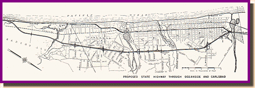
"Proposed Freeway Thru Carlsbad -
Oceanside." This diagram of the then proposed freeway is from the Bridge
Department.
Part I: Carlsbad | Part II: Oceanside
The Oceanside-Carlsbad Freeway was a 10 mile long freeway built between 1950 and 1953 to alleviate heavy traffic that had developed in the two cities and was the first modern freeway the metropolitan San Diego area. Its routing follows what is now County S21 between La Costa Ave and Palomar Airport Rd, then I-5 between Cannon Rd and the San Luis Rey River. Along with the Montgomery Freeway in the southern part of the county, this was one of the first to appear as a full, modern freeway. "Psuedo" freeways had appeared previously in San Diego County, including a section of Pacific Highway that had been upgraded in 1942. Unlike the Oceanside-Carlsbad Freeway, it was a mix of grade crossings and grade separated interchanges. This freeway represented a quantum leap in construction as shown by the fact that fully 3/4 of it is now incorporated into I-5 and that the original pavement still forms the inner lanes in many places. The freeway was completed in two major sections. The first, finished in 1952 followed what is now Carlsbad Blvd between La Costa Ave and Palomar Airport Rd. It was essentially a widening of the original three lane alignment which was done by adding the additional northbound lane. The second section was opened to traffic in 1953 and ran from Palomar Airport Rd to the San Luis Rey River bridge on completely new alignment; almost all of this is now part of I-5.
Remnants of the 1952 Freeway These pictures, taken just south of Palomar Airport Rd, show how the 1952 section was built. The southbound lanes, pictured below to the left, are the original alignment, which had been previously modified in 1928 and widened to three lanes. The picture at right shows the northbound lanes, which were built with the freeway. Essentially, the old alignment was converted from two way traffic to southbound only, having the northbound traffic using the new lanes. The concrete is original paving from the freeway. The picture at the top right shows the former Ponto Rd interchange, which was removed in 1993 by the City of Carlsbad. |
 |
 |
 |
 Looking south from the Palomar Airport Rd separation toward the 1952 alignment. The light standards are original and the grade in the foreground was part of a ramp. |
 Closer view of the actual freeway. The lanes closest to the picture are from 1952; the fence line visible in the distance is part of the 1928 alignment that still remains. |
![]()

1953 map showing interchanges on freeway. Click on image for larger
view.
 (Photographs courtesy of Caltrans Library) Above: South interchange between US 101 and Business US 101, 1953. The AT&SF grade separation is visible in the background. Right: The AT&SF grade separation viewed from the Business US 101 overcrossing. Below Left: Old Business US 101 overcrossing (Palomar Airport Rd overcrossing) in 1953. In 1966, this interchange was completely reconfigured to today's appearance (Photo courtesy of Caltrans) Below Right: Same intersection as it appeared in 1998 Note how the former freeway has been modified and how the concrete was paved over. |
Freeway / Business US 101 Separation (South) This photograph, facing north, shows a lot about the original Oceanside-Carlsbad Freeway. The interchange between "Freeway 101" and "Business 101" (the old alignment) is visible - "Business 101" followed the old alignment up the coast.. A section of the old three lane road, which exists today, is visible to the left of the concrete lanes at the bottom of the picture. The 1953 alignment starts close to the bottom of the picture and continues over the railroad grade separation. The separation, visible toward the center of the picture, no longer exists, having been removed for construction of I-5 in 1966. The section of freeway continuing in the background now forms the inner lanes of present day I-5. The coal burning power plant, a Carlsbad landmark, was under construction at this time and is visible off the old alignment, toward the top of the picture
|
 |
 |
|
|
|
| Old and New Freeways at Palomar Airport Rd,
1966
The picture above shows a unique view of the history of US 101. The construction in the foreground is I-5 at Palomar Airport Road and a short section of US 101 freeway is visible in the background. The reason this is unique is because it shows the relative location of the old and new freeways. One year later the section of US 101 freeway, including the AT&SF overhead visible in the pictures had been removed and today there is no trace. Today, even the 1966 bridge in the foreground looks different as the tube guardrail gave way to the modern fence and concrete guardrail as part of widening the bridge from two to six lanes. |
|
Close-up of the
still existing Carlsbad Blvd bridge |
Close-up of the
since removed AT&SF overhead |
![]()
Continue to the Oceanside Bypass
 |
US 101 Page Go to the pre freeway alignment Continue north on US 101: Camp Pendleton |

Go to the Historic California US Highways Main Page
![]()
http://www.gbcnet.com/ushighways/US101/carlsbad_fwy.html