
| |
US 395 Photo GallerySan Diego County |
City of San Diego | North San Diego County
 |
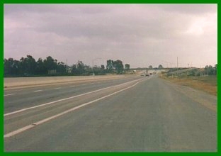 |
| US 395 was widened and realigned in 1950. The picture on the left shows US 395 near Linda Vista Rd. at Kearny Mesa; this is near the current intersection of present SR-163 and Clairemont Mesa Blvd. The picture at right shows the 1950 alignment about 5 miles to the north of the other photograph at Kearny Villa Rd. and Miramar Way. This section was converted into freeway in 1968 and bypassed by the eight lane I-15 in 1984. | |
 "This view is looking north on the new route." |
 Kearny Villa Rd. in the same location as the picture at left, 1997. |
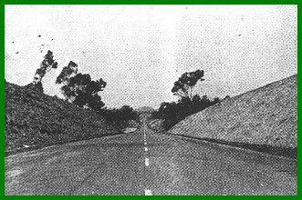
| These pictures show more of the 1950 alignment. While parts of it were full four lane divided expressway, most of the alignment was still two lane undivided, though limited access. This new alignment was shifted west to follow about the current alignment of I-15. | |
"Transition
from four to two lanes." |
"Looking
north on the new route, showing transition from four lanes to two lanes." |
| Clairemont Mesa Blvd Interchange, 1959
Portions of the 1947 expressway were upgraded to full freeway status by the end of the 1950s. An example of this is the intersection with Clairemont Mesa Blvd. Much has changed since these pictures were taken in 1959; the surrounding area is almost completely built out. The freeway itself is now eight lanes wide and Clairemont Mesa Blvd has been widened with a parallel bridge. The overcrossing is still there, complete with the steel guardrails and the cloverleaf turns still exist.
|
 |
 |
| Pomerado Road
US 395 used to follow Pomerado Rd. between the current I-15/Miramar Rd. interchange to the the interchange with I-15 near Lake Hodges. The picture at left shows US 395/Pomerado Rd. before 1950; this road resembled the Ridge Route to the north with its sharp curves, steep grade, and the narrow single slab concrete. The picture at right shows this same section of road in 1997 - note that the curve in this picture is the same as the curve on which the two cars are driving at left. Most of this alignment has been covered over by a major straightening of Pomerado Rd. in the late 1980s. |
|
 |
 |
|
Los Peńasquitos Creek Arch Bridge This arch bridge over Peńasquitos Creek was completed in 1949. It is a reinforced concrete open spandrel* arch bridge with an overall length of 434 feet and an arch span of 220 feet - an impressive structure. The current I-15 bridge was first built in 1966 as the southbound lanes of the US 395 freeway; the old bridge stayed in use as the northbound lanes (see picture at bottom right). It was completely replaced in 1976 by the widening of the newer bridge. I had initially believed this bridge had been removed to accommodate the newer bridge, but was pleasantly surprised to find it still standing, despite its being used as a staging area for a nearby construction project. * Spandrel means the area between the exterior curves of two adjoining arches or the area between the curves of the arch and the framework enclosing it. In other words, open spandrel refers to the open design of the bridge |
|
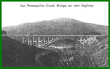 Picture of bridge in 1950 |
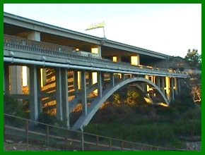 Los Peńasquitos Creek bridges, 1997 |
|
|
| Carmel Mountain Road (1967)
In 1966 US 395 was upgraded to full freeway between Miramar NAS and the southern city limits of Escondido, just north of the Lake Hodges bridge. Just ten years later in 1976, many of the bridges were either removed or widened as part of a project to convert I-15 to eight lane freeway. This bridge is one that was removed in 1976 and shows what other bridges looked like along the freeway, such as the 1966 Peńasquitos Creek bridge. At this point, I-15 officially ended at I-10 in San Bernardino and this freeway was entirely US 395 as shown in the sign shown in the enlargement below.
|

Above: Carmel Mountain Road overcrossing in 1967. Note the use of yellow striping in the middle of the road; this is the earliest I have seen it used. Left: Since I-15 ended in San Bernardino, this freeway was signed solely as US 395. This has significance since this freeway was built as US 395 after the 1964 renumbering and was not at the time considered a future upgrade to an Interstate highway. |
 |
 |
| Two views of four lane US 395 expressway. The photo on the left is from 1952 and shows a brief section of expressway that was in use until the eight lane I-15 covered it in 1973. It is located on the grade just to the south of the I-15/SR-79 intersection. The photo at right shows the US 395 expressway just to the north of Escondido in 1997; it was bypassed by I-15 in 1976. |
![]()

Go to the Historic California US Highways Main Page
![]()
If you have any questions, comments, or if you would like to send me any updates or pictures, please contact me at: casey@gbcnet.com
http://www.gbcnet.com/ushighways/395pics1.html


