
| |
US 80 Photo GalleryLaguna Mountains - West |
 Click on image for larger view. (~30 Kb) In San Diego County, between The Willows and Descanso Junction There were several major realignments of US 80 in the early 1950s, as evidenced by this map from the Division of Highways' California Highways and Public Works. |
![]()
| The route of US 80 over the mountains east of San Diego posed a formidable challenge to highway engineers due to their ruggedness. As highway engineering advanced, sections US 80 were rebuilt and realigned utilizing the latest techniques. The first alignment of US 80 was built in the early 1920s and the final modifications before I-8 was built were completed in the early 1950s. Fortunately, much of US 80 still remains, mostly untouched in this area and provides an interesting study in the evolution of highway engineering. |  Caption: New alignment of US 80 east of Alpine. Construction and paving
operations. US 80 under construction east of Alpine, 1951. |
![]()
 |
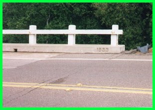 |
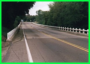
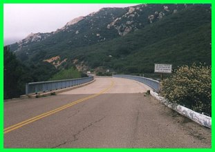
| US 80 bridge over Viejas Creek. As the date stamp indicates, this bridge was built in 1933 and is typical of bridges on rural US highways as it has wooden rails instead of concrete barriers. This section was bypassed in 1952 with the opening of the bypass shown on the map above. | |
 |
Three Incarnations of US 80The picture at left shows two alignments of US 80 and the current alignment of I-8. From left to right: The 1930s alignment of US 80 cuts through the ridge and the 1920s alignment, which rounded it and is barely visible as a smaller cut just to the right of the big cut. I-8, built in 1970 is to the far right. |
| Rest area on US 80. The tree and the remnants of a stone wall are all that is left of this rest area. Unlike the ones on today's Interstates, this rest area had no restrooms and simply consisted of a turnout and a shaded picnic area. The nearby road has since been covered by earth due to over 25 years of abandonment. |  |
 |
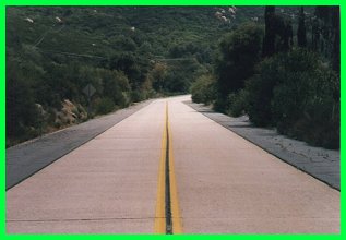 |
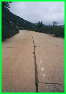
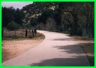
| Wildwood Glen Lane. This is the first section of US 80 east of San Diego in which the original concrete remains exposed most of which is in pristine condition. The picture on the left shows an abandoned section with the original white line down the middle. The above photograph shows a nearby county maintained section with well maintained shoulders which give an idea of how US 80 looked. The yellow line is a later addition. |
 |
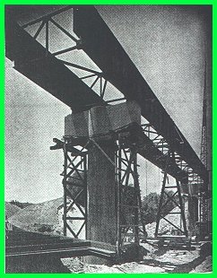
Sweetwater River BridgeThis bridge, which was completed in 1951, replaced an older, dangerous bridge which was the site of many accidents; it in turn was replaced by I-8 in 1970. Top left and above: the bridge under
construction, 1951. |
 |
![]()
 |
 |
| Interstate 8 postmile marker. While US 80 remained signed as such until it was replaced by the new interstate freeway, it officially became Interstate 8 on July 1, 1964 as the marker attests. | Mountain section. This section shows the rugged terrain that US 80 crossed. It also demonstrates how well engineered US highways had become. |
 |
 |
| Original alignment. This alignment of US 80 dates from 1915 and was single slab of concrete 16 feet wide. While most of it was covered by later alignments of US 80, some pristine sections remain, such as the one above and some sections in the desert. It is also interesting to note the similarity it has to the Ridge Route to the north; both roads were constructed in the same era. | |
![]()
![[Highway 80]](../logos/80_shield.gif)
|
Continue to Jacumba. Return to the US 80 Page. |
![[Historic Highways Logo]](../logos/small_hcuh_banner.gif)
Go to the Historic California US Highways Main Page
![]()