
| |
US 80 Photo GalleryImperial County |
| Just like San Diego County, most of the original alignments of US 80
remain in Imperial County. While the remaining highway is not in as good shape as San
Diego County, Imperial County has signed it as County Route S80 as a fop to its former
designation. A lot of interesting sights still exist along this stretch of old US 80
including the old plank road used from 1916 to 1927 and the cantilever bridge built across
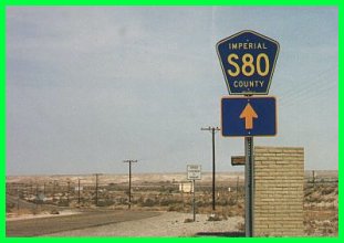
the Colorado River near Yuma in 1916. About half of old US 80 is signed as County Route S80 as this sign in Octillo attests. |
 |
 |
 |
| The wood bridge above is typical of the type built on California desert highways in the 1920s and 1930s. Unlike the bridges on other major desert highways, this was not refurbished in the 1950s with a concrete deck; it appears as it did when it was first built. | The section of highway shown above is unusual for a desert highway. Most were paved with thin oiled macadam; concrete was used very rarely since it does not hold up as well as asphalt to the temperature extremes found in the desert. This dates from around 1916 and was built next to the former San Diego and Arizona Eastern railroad tracks, visible to the right. |
(Photograph courtesy of Caltrans.)
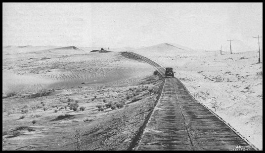
The Sand Hills and Plank RoadThe old plank road along US 80 is one of the most famous sections of historic highways. It was built over the Algodones Sand Dunes (or more commonly Sand Hills), which posed a formidable engineering challenge, since the dunes shifted constantly, making a fixed road impossible. The plaque at right describes it best: * Plank Road * 1914 - 1927 This unique plank road seven miles long was the only means early motorists had for crossing the treacherous Imperial Sand Dunes. The eight by twelve foot sections were moved with a team of horses whenever the shifting sands covered portions of the road. Double sections were placed at intervals to permit vehicles to pass. California Registered Historical Landmark No. 845 |
 |
 |
 |
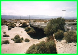
The All-American CanalThe All-American Canal brings water from the Colorado River to irrigate over half of the Imperial Valley. It it is called "all-American" since no part of it enters Mexico; previous canals had to go south of the border and deal with the water rights issues associated with so doing. While the canal has enabled the Imperial Valley to prosper, it is also largely responsible for the Colorado River no longer reaching the ocean. It is easy to understand why this is the case upon viewing the canal, which is itself the size of a river. When it was completed in 1939, it was considered a miracle of modern engineering and still is today, especially the segment that traverses the sand hills. The structures over which US 80 crossed the canal are just as impressive, especially the bridge pictured at left. Top Left: High level bridge over canal built in 1938; the picture is from 1959. The bridge still exists: it is now crossed by the westbound lanes of I-8. (Photograph courtesy of Caltrans.) Bottom Left: Lower level bridge west of Winterhaven, built in 1938. Below: Canal and highway (thick and thin lines respectively) across the sand dunes. (Photograph courtesy of Caltrans.) |
 |
 |
Colorado River Bridge (1916)This cantilever structure was built in 1916 to complement the newly built plank road under the Bureau of Indian Affairs. It is located to the east of the later crossings and next to the Southern Pacific Railroad crossing. Today, the bridge looks way too high compared to the level of the river. However, before the construction of all the dams upstream, the Colorado River used to flood this area regularly, sometimes with levels reaching the bridge. This bridge was bypassed in 1956 by the one shown below; it was spared from demolition because it serviced the local Indian school. The 1956 bridge was bypassed in turn by a high level viaduct which now carries I-8 over the river in 1978. A portion of the viaduct is visible in the top picture, just to the right of the bridge. Today the bridge is closed to vehicular traffic, due to the combination of its narrow deck (20') and insufficient structural soundness. It is still used as a foot and bike path. |
 |
 |
 |
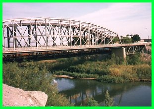
Colorado River Bridge (1956)This bridge crosses the Colorado River between Yuma, AZ and Winterhaven and was completed in 1956. It is a four lane structure which replaced the narrow two lane cantilever bridge built in 1916 (mentioned above) and was financed jointly by the States of California and Arizona and designed under the auspices of the California Division of Highways. An interesting feature of this bridge is that it was built well above the record flood level, even after the completion of the dams upriver. |
![]()

|
Go west to Mountain Spring. Return to the US 80 Page. |
![[Historic Highways Logo]](../logos/small_hcuh_banner.gif)
Go to the Historic California US Highways Main Page
![]()
http://www.gbcnet.com/ushighways/80pics_e.html