|
US 80: Imperial ValleyThe
Plank Road and
|
Acknowledgement: Much of the
material for this topic has been adapted from a 1961 article in California Highways
and Public Works by Jacob Dekma titled "The Sand Hills."
See the footnote below for more details.
See Also: US 80 - 1961 Freeway Construction Across the Sand Hills
 |
Turnout in the Plank Road, c. 1920sFor most of its length, the Plank Road was an 8' wide strip of wood. However, it was necessary to provide turnouts every 1/4 mile to allow passage of vehicles going in opposing directions. Fistfights often ensued when vehicles would not yield to each other on the narrow sections. This picture shows a typical turnout and is facing east. Note the section in the middle covered with sand and maintenance crew with horses. These crews moved the sections that were covered with sand using the horses. |
Location and Background
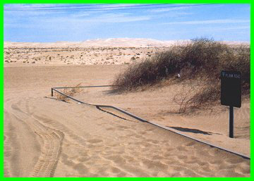
The Plank Road that crossed the Algodones sand dunes is one of the most notable, if not unusual US highway artifacts. To visit a surviving portion of the Plank Road exit I-8 at the Gray's Well. The sand dunes have become a center of dune buggy activity and the dunes are infested by swarms of these vehicles on the weekends. This area is also the site where some the desert scenes from "Return of the Jedi" were filmed. In fact, the mountains to the east are recognizable in the film and some of the features in the image to the right should look familiar. After the freeway over crossing, Gray's Well Rd. turns sharply to the right and follows the old alignment of US 80 briefly. It is still plainly visible where the old alignment veers to the right and goes under the freeway. The road backtracks next to I-8 and after about one mile, turns sharply to the left and rejoins the old alignment; again it is plainly visible where the old alignment comes back out of the freeway. After about another mile, the road goes down a hill and a surviving portion of the old plank road is visible to the left. |
|||
 |
This portion of plank road is the last one surviving - according to the signs posted by the Bureau of Land Management (B.L.M.), it is the last known section remaining of such a road anywhere. In the past, people have taken pieces of the road and used them for firewood, not seeing the value in preserving it. General Patton's troops did much to destroy it during their training in the area during World War II. It is fortunate that the B.L.M fenced off this last section and made it an historic landmark. There are signs telling of the history of this road as well as two replicas of the two track and later versions of the road. It is well worth the time to have a glimpse at this piece of our history. | ||
|
Remnants of the Plank Road, 1961 |
|||
|
|
|||
 |
While it may seem crude by today's standards, the Plank Road was a marvel of modern engineering during its time. It went across the Algodones sand dunes, located in the middle of one of the hottest places on earth - the arid desert of the Imperial Valley. They were a nearly impossible barrier to cross. Even the '49s (some of whom braved the swamps of Panama) gave them a wide berth. Later, there were legends of wagon trains being completely swallowed up within the dunes. The fact a road was successfully built across these dunes is a testament to the ingenuity of the men who built it. |
|
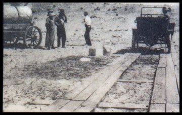
First incarnation of the Plank Road, 1915 |
|
It is easy to see how the sand hills were such an obstacle. The hills
themselves are actually a sea of rounded particles of sand and are up to seven miles wide
and over 50 miles long . It becomes clear how they have long posed an almost
insurmountable barrier to travel. They drift with the wind and never stay in one place.
Some parts move at a leisurely rate of only a few feet per day, while other parts can move
up to 50 feet per hour. In this context one can see the difficulty of building any solid
passage over these dunes There were two incarnations of the Plank Road. The first was privately funded through the efforts of San Diego businessmen who in 1912 sought to attract visitors from the east. An interesting note is that this was spearheaded by Ed Fletcher of San Diego who later rose to prominence as Director of the California Public Works Department. In 1915 the road was put into place. The road itself was not much: it consisted of two pairs of three 1' wide planks all held together by 1' wide cross members divided into sections (see pictures above and to the right.) A section could be moved by one man when it became covered with sand. As one would expect, it was a difficult road to drive on as there was not much margin for error in keeping the wheels on the track. However, it proved that a road could be built across the Sand Hills. The first version of the Plank Road lasted for only a year. The completion of the "Ocean to Ocean Highway" Bridge in 1915 over the Colorado River at Yuma increased the amount of traffic on the road, necessitating the construction of a new version. Its success prompted the California Highway Commission to build a more improved and permanent version in 1916. This version consisted of 8' wide railroad ties dipped in tar and placed next to each other lengthwise to the road. The road was made up of 8' wide by 12' long sections, weighing 1500 lbs. each and held in place by iron bars bolted to the ties (As shown in the picture to the right.) Since this amounted to barely a one lane road, extra 8' wide sections were placed sideways every 1/2 mile, acting as turnouts. Needless to say, this created a lot of conflict as drivers expected the other to use the turnout. Many fistfights ensued over who was to back up and wait in the turnout. |

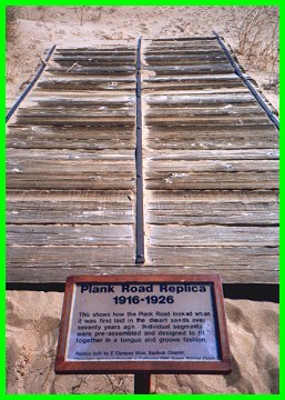
Examples of old plank road construction by the B.L.M. Photos taken 1998.
|
The sections were placed by an apparatus pulled by mules (pictured at left, below), with one placed after another. They were stacked on this apparatus and then dragged to the placement site. The workers employed a series of pulleys and windlasses to pull the sections up and place them properly. The sections fit into each other using a tongue and groove connection that proved effective in keeping the pieces together. The work was done entirely by man and beast as there were no mechanical devices to use for this work. That this was all done under a sweltering desert sun adds to magnitude of this accomplishment. |
|
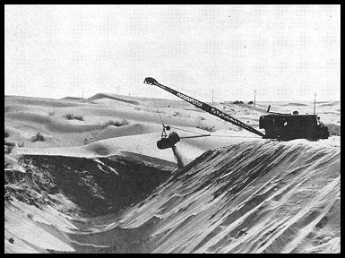
1926 Paved Road Crosses Dunes
"One of the big routing problems on the California highway system is that through the shifting sand hills between Yuma and Holtville. This section is now traversed by a plank road. The final solution the problem appears to be to locate the road south of and away from these shifting sand dunes. To do this, however, would require that for a distance of approximately 15 miles, the state highway be built in Mexican territory. proposal, as published in the Road building technology advanced significantly between 1916 and 1925. There is no place where this is more evident than the road across the Sand Hills. In 1916 is was considered a marvel that the dunes could even be traversed, albeit by a less than conventional road. At the time, the idea of creating a conventional paved road across the dunes was unimaginable. By 1925, an ingenious method was devised for placing a 20' wide paved road, one that would make driving across the sand hills no different than crossing any other kind of terrain. Operations for the new road started in 1925 and by August 1926 the new road was opened, leaving the Plank Road as an historical curiosity. |
|||
|
|||
 Paving the Sand Hills road, 1926. The timbers at right supported the paving trucks as they went over the sand. |
 The completed road and All-American Canal as they appeared in 1961. The complex in the front is a former canal maintenance station now covered by the Gray's Well rest area. View is looking west. |
||
|
|
|||
 |
US 80 Side Trips:Continued: East: All American Canal and Colorado River
Crossing Return to the US 80 Travelogue |
![[Historic Highways Logo]](../logos/small_hcuh_banner.gif)
Go to the Historic California US Highways Main
Page
![]()
http://www.gbcnet.com/US80/US80_plank_road.html