Photo Gallery
| |
US 91 and SR-18 Photo Gallery Santa Ana Canyon Road |
1935 Alignment | 1952
Expressway | Corona
| US 91 was originally built through Santa Ana Canyon between 1935 and
1938 as SR-18. In 1947, the road was given the additional designation of US 91 when that
highway was extended south from its original terminus in Barstow. The road was originally
two lanes wide, paved with twin slab concrete. In 1951 this road was converted into a four
lane expressway. On July 1, 1964, the US 91 and SR-18 designation was dropped and replaced
by Legislative and State Sign Route 91; the previous four lane expressway is now covered
by the SR-91 (Riverside) Freeway. In several places along Santa Ana Canyon, curves and
grading from the old road are still visible Looking east toward Santa Ana Canyon along US 91 / SRŁ18. |
 (Photograph courtesy of Caltrans_ (Photograph courtesy of Caltrans_ |
![]()
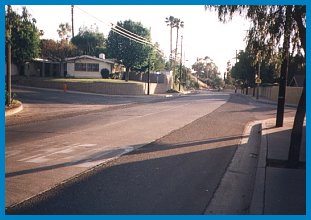
The pictures below show a well preserved section of old Santa Ana Canyon Rd. When it was built in 1935, it ran through prime farmland, though now that has been covered over by houses, reducing Santa Ana Canyon R. to the status of a tertiary arterial. This was originally built as SR-18, and ran from the intersection of Orange-Olive Ave. in Orange to the Riverside Ł Orange County Line. It also carried the US 91 shield from 1947 to the time it was bypassed by the new expressway (now the SR-91, Riverside Freeway) in 1955.
![[US 91 in Orange]](../us_pix/91_pics/91-2_lane2.jpg) |
![[US 91 in Orange]](../us_pix/91_pics/91-2_lane3.jpg) |
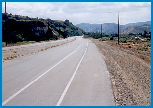
| Santa Ana Canyon Rd. in Orange. This pristine section is 1 1/2 miles long and looks almost identical to the way it looked when it was built. In particular, notice the wide asphalt shoulders, typical of highways of the era as well as the banked turn evident in the picture to the left. | |
![[US 91 in 1934: Before]](../us_pix/91_pics/91-2_lane_1935a.jpg) |
![[US 91 in 1935: After]](../us_pix/91_pics/91-2_lane_1935b.jpg) |
| SRŁ18 under construction through Santa Ana Canyon.
These before and after pictures show sections of highway similar to the one pictured in
Orange under construction. The picture in the middle of the surviving section shows how the
highway looks in a modern setting. (Historic photographs courtesy of Caltrans) |
 |
![[US 91 in Orange]](../us_pix/91_pics/us-91_2_lane2a.jpg) |
![[US 91 in Orange]](../us_pix/91_pics/us-91_2_lane2b.jpg) |
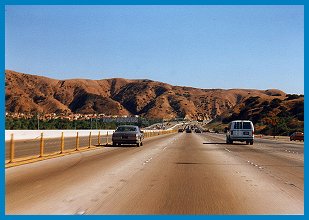
By the end of the 1940s, Santa Ana Canyon Rd. had become a major and heavily traveled route. As acknowlegement of this, in late 1946 this was designated as part of US 91. Of course signing this road as US 91 was just the start; the road needed to be an expressway. By 1952 the old two lane concrete road had been upgraded to the more modern four lane divided expressway visible in the pictures. Even though this highway had at-grade crossings, it was still called a "freeway" due to the fact it was limited access.
![[4 lane alignment - 1952]](../us_pix/91_pics/91-4_lane_canyon.jpg)
|
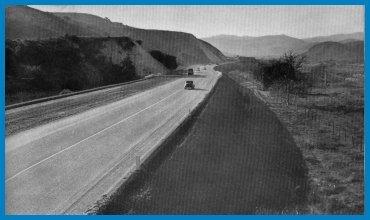
![[Expressway in Santa Ana Canyon, 1952]](../us_pix/91_pics/91-sa_canyon_expwy2.jpg) |
| Above Then and now: these
pictures were taken near the location of the current SR-91 and SR-241 (Eastern
Tranportation Corridor) interchange. Right Caption reads: "This shows another section of the completed access freeway on Santa Ana Canyon Road." Below Caption reads: "Completed construction of four-lane, limited access freeway on Santa Ana Canyon Road in Orange County. |
|
![[91 Expressway, 1952]](../us_pix/91_pics/91-sa_canyon_expwy.jpg) |
|
While Santa Ana Canyon Rd. had been improved to the Riverside County line in 1935, that point marked the limit of the project. It was not until 1939 when work could proceed east of the county line. This was because of the construction of Prado Dam which would determine the final alignment. The old alignment (pre-1939) is currently under the reservoir created by Prado Dam along with the town of Prado; the 1940 alignment, along with the railroad tracks, was built along the south bank of the Santa Ana River and was well above the level of the river. This was particularly significant since the floods in March, 1938 had caused significant damage to the older road.
 This is the original alignment that was bypassed in 1938 looking toward the Prado Dam near Corona. |
 The original alignment was originally paved with 18' concrete typical of the late teens and early '20s. |
Prado Dam Relocation (1939) This section of highway was completed in 1939 as a two lane road on a four lane alignment and widened to four lanes divided in 1950 as shown by the stamp below. In 1970, the current SR-91 freeway was built, bypassing this section; a result of the construction was the the area on the right side of the pictures was filled in. The bridge at right is dated 1938 and has the all-wooden guardrail typical of rural bridges from this era. It also has the recessed divots which used to contain reflective paint. The three historical photos below are from the February, 1940 issue of California Highways and Public Works. |
![[West of Corona, 1997]](../us_pix/91_pics/91-1938_br.jpg) |
|
 Same location, 1998 |
 |
 |
"Relocation of the Santa Ana Canyon Highway necessitated by construction of Prado Dam across the Santa Ana River for flood control in Orange County between Corona and the Orange County Lin, takes the highway and Santa Fe Railroad, both of which were flooded in 1938, high above the river. In addition, the more direct route shortens the distance about a mile and eliminates many sharp and dangerous curves." (California Highways and Public Works. March 1940) |
|
 |
US 91 Photo AlbumRiverside Go south on US 91 and SR-18 toward Long Beach. (Future) |
![[Historic Highways Logo]](../logos/small_hcuh_banner.gif)
Go to the Historic California US Highways Main Page
![]()
http://www.gbcnet.com/ushighways/91pics2.html