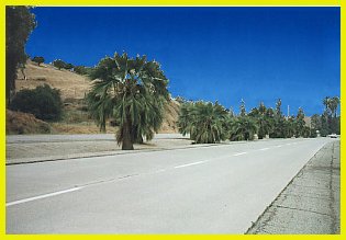
US 99 Expressway, Redlands
This was one of the last sections of US 99 to be converted into four lane divided highway. This section is located near the eastern city limits of Redlands, near the point where I-10 descends from the mountains.
|
US 99 Expressway, RedlandsThis was one of the last sections of US 99 to be converted into four lane divided highway. This section is located near the eastern city limits of Redlands, near the point where I-10 descends from the mountains. |
Even though the San Gorgonio Pass offers the easiest access to metropolitan Los Angeles, there are still hills to be negotiated. While they are generally low and rolling, they posed an obstacle to the railroad; as a consequence it splits from US 99 (I-10) just west of Banning, following San Timiteo Canyon and rejoins US 99 at the outskirts of San Bernardino. San Bernardino was established as a Mormon settlement and marked the end of the Mormon Trail. This trail paralleled what is now I-15, although it ended its passage over the San Bernardino Mountains near the present route of SR-18. San Bernardino lies in a valley formed by creeks that drain the nearby mountains; the Santa Ana River and Cajon Creek are the two major ones. One result is that this valley made excellent farmland since the creeks deposited the fertile soil from the mountains. Of course, it is now very rare to see any farmland. San BernardinoIt has been successful due to its position at the crossroads of the route going north and the route heading east. Today San Bernardino is the most populous city of the Inland Empire and it continues to grow as more people flee from the suburbs of Los Angeles and Orange County.
|
US 99/70 expressway west of Beaumont shortly |
The current freeway from west of the SR-60 interchange to Yucaipa was built in 1965 and in many places it covers the old alignments of US 99. The original alignment of US 99 was built in the 1910s as part of the state highway system authorized by the bond act of 1909. It appears no part of this original alignment is still visible since it has long since been covered by the major changes later alignments brought. The first visible alignments include concrete dating back to at least 1930. Parts of this two lane alignment still exist on the current freeway as evidenced by some bridges being completed by 1937. Around 1950-51, the two lane highway was converted to a four lane expressway, which is pictured to the left. Both of the period in which the two lane highway and the expressway upgrade were completed are the same as other stretches of major US highways. The two lane stretches were built in the 1930s as part of the Works Progress Administration (WPA) and these were then converted to four lane expressways in the late 1940s, early 1950s time frame.
From 16th St. in Yucaipa to the intersection with I-215, the six lane freeway was built in 1962 as a part of I-10, but was also signed as US 70-99. This freeway also covers the old alignment of US 99 to the Redlands Blvd exit, although part of it are still visible on both sides. US 99 followed Redlands Blvd all the way to just short of the interchange with I-215, or as it was before 1964, US 91 and US 395. Right after the freeway exit, Redlands Blvd becomes another very well preserved section of US 99. It is a four lane dived road which resembles what the rest of the US 99 expressway looked like, especially since this section still retains the original concrete. It appears the south side (going eastbound) is the older 1930s highway and the westbound lanes were added to make it an expressway. This amazing stretch of highway is over two miles long, but after the intersection with Colton Blvd the concrete is covered with asphalt. However, there are still many traces of US 99 including the old style curbs with divots and several old bridges. Also, many businesses that line Redlands Blvd date to the US 99 days. Redlands Blvd continues to just a little to the east of the I-10/I-215 interchange.
The I-10/I-215 interchange, which was built in 1958 and modified in 1972, covers the old alignment of US 99. Some old bridges from the 1958 interchange are still in use. Until 1999 there were two bridges on I-215 that retained the telltale concrete "arch" railings, but now have the customary jersey curb railing. One of the bridges over the Santa Ana River, on the westbound side, was built in 1937 (though subsequently widened) and carried the original alignment of US 99. From this interchange, I-10 (and US 99 before) is known as the "San Bernardino Freeway" to US 101 just east of downtown Los Angeles.
Beyond the I-215 interchange the freeway was built in 1956. For the short time in 1958-59, this was signed with US 91, US 395 and SSR 18 the interchange to 10th St. The original alignment of US 99, Valley Blvd, splits off to the north at the Mt Vernon exit. The previous incarnations of the interchange with US 91/US 395 are about a mile to the west of the current location. The original interchange is the intersection of Valley Blvd and La Cadena Dr. (8th St.) and the second, which was active for only two years, is where the freeway crosses over La Cadena drive.
Continuing west, US 99 followed Valley Blvd prior to the completion of the freeway. In many places there are telltale signs that Valley Blvd. used to be concrete as the cracks show through the asphalt. It looks as though Valley Blvd. looked as it does now, with four lanes and a center turn lane. A small segment of the 1920s era alignment is visible to the right just before the Sierra Ave. intersection. A few miles to the west, Valley Blvd goes under the freeway. The freeway was originally built as an expressway in 1946-47 and converted to a limited access highway in 1956. It was widened between 1964 to 1970 to its present eight lane incarnation. Unfortunately, with the exception of a few bridges, there is very little that shows of the old alignments.
![]()
 |
North: Los Angeles (South) South: Coachella Valley |
![]()
![[Historic Highways Logo]](../logos/small_hcuh_banner.gif)
Go to the Historic California US Highways Main Page
![]()
* Thanks to Joel Windmiller for the scan of the original US 99 expressway.
