
| |
US 80 Photo GalleryMountain Spring and
|
| The crossing near Mountain Spring has always presented a
formidable barrier for travelers, but has also been the key to entry to the San Diego area
from the east. The Yuma and In-Ko-Pah Indians (for whom the In-Ko-Pah Gorge is named) used
this route to get to their winter fishing areas near what is now San Diego. By the early
1900s a narrow and winding paved road was built over the difficult terrain in the area - a
miracle of modern engineering as it was hailed at the time, but it wasn't until 1940 that
a modern road was completed. In 1963, Interstate 8 was completed, making passage through
Mountain Spring an easy affair with little hint of the previous difficulties. Fortunately
for highway fans, there is a lot of the old road remaining, as shown in this section of
the US 80 Photo Gallery. Right: Early alignment at the top of Mountain Spring grade. This picture gives an idea of the rugged terrain with which the highway builders had to deal and the narrow and tortuous nature of the old highway. (Photograph courtesy of Caltrans Library.) |
 |
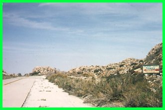
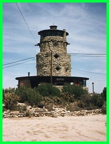
Desert Kitsch (Desert View Tower)The Desert View Tower has long been a landmark for travelers on US 80. This odd four story structure was built by Burt Vaughn in 1922 to honor the pioneers who struggled across the arid desert. Today it houses an interesting museum which features a variety of things best labeled as "Americana." It also has a gift shop where one can purchase their own pieces of Americana. There are some interesting caves to the outside which were carved during the Depression by an out-of-work engineer named W.T. Ratliffe, and like the tower are a tribute to those early pioneers. Admission to both the tower and the museum is $3 and is worth it if just for the incredible view. Several of the pictures I took that appear in the Mountain Spring Grade section below were taken from the top of the tower. Below: These photographs show the approach to the Desert View Tower which consist of pristine sections. The sign on the top photograph is advertising for the tower. |
Above: The Desert View Tower, long a familiar sight to travelers through Mountain Spring |
 |
 |
Mountain Spring Grade: Old and New
|
|
 |
 |
 |
Above: A contrast in
roads looking down the grade. The 1940 alignment, which still followed the contours
is cut through by I-8, built in 1964. Both pictures were taken from the Desert View Tower. Left: Another view of the 1940 alignment at the bottom of the Mountain Spring grade. While the curve is very gentle, especially compared with the old road (at left, not visible), the Interstate through this area has curves with over twice the radius, allowing a design speed of 70 MPH. |
![]()
Mountain Spring Relocation (Late 1930s)
|
|
 |
First Paved Road The pictures at left show the first paved road to make the rugged descent from Mountain Spring to the desert floor of the Imperial Valley. The completion of this narrow road represented a quantum leap in the ease of getting from San Diego to points east. Prior roads were little more than Indian paths converted into wagon roads. In fact, one toll road built in the 1850s and replaced by the paved road had slopes up to 30%. |
 (Photographs courtesy of Caltrans Library.) |
|
![]()
|
Go west to Jacumba. Continue to Imperial County. Return to the US 80 Page. |
![[Historic Highways Logo]](../logos/small_hcuh_banner.gif)
Go to the Historic California US Highways Main Page
![]()
http://www.gbcnet.com/ushighways/80pics_d.html
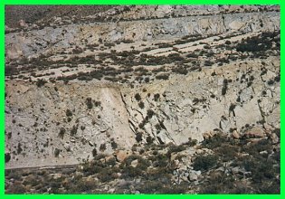
 The following
photographs show the marked difference between the old and new alignment of the highways
over the summit with the Desert View Tower in the lower middle. The road from the 1920s
has been bisected in several places by the freeway built in 1964, as shown by the picture
at right. The old 20' alignment, which is the lighter line forming an "L" in the
middle of the stands in stark contrast to the four lane freeway, which is the two lines
cutting the page diagonally. The pictures below show the old section of highway pictured
at right at surface level. (Aerial photograph courtesy of USGS.)
The following
photographs show the marked difference between the old and new alignment of the highways
over the summit with the Desert View Tower in the lower middle. The road from the 1920s
has been bisected in several places by the freeway built in 1964, as shown by the picture
at right. The old 20' alignment, which is the lighter line forming an "L" in the
middle of the stands in stark contrast to the four lane freeway, which is the two lines
cutting the page diagonally. The pictures below show the old section of highway pictured
at right at surface level. (Aerial photograph courtesy of USGS.)